National Surveyors Week: Andrew Ellicott and the City of Warren

Photo submitted to the Times Observer Andrew Ellicott, a renowned surveyor and astronomer, played a pivotal role in surveying and laying out the City of Warren in 1795, leaving a lasting impact on American history and development.
As National Surveyors Week ends, Joe McGraw, a local surveyor and president of the Northwest Chapter of the PA Society of Land Surveyors, is calling attention to Andrew Ellicott.
Many influential American figures, including George Washington, Abraham Lincoln, and Thomas Jefferson, began their careers as land surveyors. In surveying circles, Mount Rushmore is often humorously referred to as “three surveyors and that other guy.” While these well-known presidents played essential roles in shaping the country, another surveyor, Ellicott made an equally significant impact in the founding and layout of Warren.
Ellicott, one of the most skilled surveyors and astronomers of his time, was commissioned by the Commonwealth of Pennsylvania in 1795 to survey and lay out the towns of Erie, Waterford, Franklin, and Warren. Along with General William Irvine, he also determined the boundaries of the Erie Triangle. Ellicott contributed to surveying projects such as completing the Mason-Dixon Line, surveying Pennsylvania’s western boundary (later called “Ellicott’s Line”), and laying out the City of Washington, D.C., at the direction of President George Washington.
Warren’s survey took place in September and October of 1795, following the completion of the Erie survey. On September 22, Ellicott and his team departed Erie, passing through Fort Le Boeuf before reaching the future site of Warren on September 30. Ellicott described Warren as a plain of about 300 acres along the right bank of the Allegheny River, just below the mouth of the Conewango. The town was laid out along the riverbank with a central square designated for public buildings.
During their work, Ellicott and his crew frequently interacted with Native Americans, who welcomed the prospect of a nearby town for trade. The Native Americans often brought potatoes, beans, squash, pumpkins, and fowl to exchange for bacon, salt, soap, or money.
In a letter to his wife Sally, Ellicott described the hardships of the survey, including illness among the crew and their worn-out clothing. He mentioned suffering from “ague,” now known as malaria, and treating it with willow bark, a common remedy at the time. The survey was completed on October 13, 1795, and the crew then traveled to Venango in the snow, facing further hardships, including the death of one crew member who was buried along the riverbank.
Ellicott’s Lasting Legacy
After completing his work in Pennsylvania, Ellicott significantly contributed to surveying and science. He settled land disputes in Florida, Georgia, and North Carolina, worked for the Pennsylvania Land Office, and later became a mathematics professor at the United States Military Academy at West Point. In 1803, President Thomas Jefferson enlisted Ellicott to mentor Meriwether Lewis in surveying and astronomical observation for the Lewis and Clark Expedition. Another notable achievement was his re-survey of the Collins-Valentine Line, which defines the boundary between Quebec, New York, and Vermont.
Ellicott passed away on August 28, 1820, at his home in West Point. He remained dedicated to accuracy, integrity, and scientific advancement throughout his life. His work in Warren and beyond was instrumental in shaping the United States, and his legacy continues to be honored by surveyors today.
Local News

Crimestoppers offer reward in kitten cruelty case
Man serving time pleads guilty to child porn
A former Pittsfield resident already serving prison time for possession of child pornography will spend more time ...
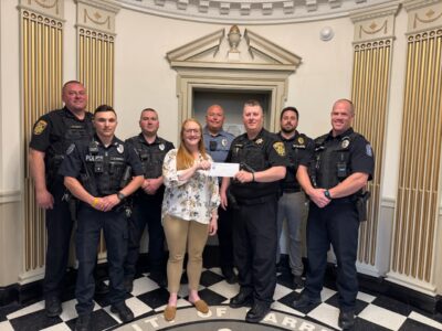
Scoring for Safety: Lodge 83 donates $1,000 to launch Youth Football fundraiser
Man jailed after alleged threats against Democratic lawmakers
Scranton mayor outraises state congressional candidates in April
No congressional candidate in Pennsylvania raised more than Democrat Paige Cognetti’s campaign in April, ...
State pushing highway, technical careers
On Wednesday, the Pennsylvania Departments of Transportation (PennDOT) and Education (PDE) invited schools to take ...